
Severe Storms Batter Northeast Oklahoma, Tornado Threat Looms Through Weekend
A dangerous and evolving weather situation is unfolding across northeastern Oklahoma, with multiple rounds of severe storms expected to impact the region from Thursday night through Sunday. Areas including Tulsa and surrounding counties are already under active warnings, as meteorologists track a volatile system capable of producing large hail, damaging winds, and isolated tornadoes.
Authorities have urged residents to remain alert as conditions are expected to worsen overnight and continue into the weekend, raising concerns about flash flooding and repeated severe weather outbreaks.
Active Warnings and Watches Across the Region
As of late Thursday night, a severe thunderstorm watch remains in effect for a large portion of northeastern Oklahoma, southeastern Kansas, and parts of northwestern Arkansas. The watch is expected to remain active until at least 4:00 a.m., with additional alerts possible overnight.
Several counties have already been placed under severe thunderstorm warnings, including Nowata, Rogers, Tulsa, and Washington counties. These warnings indicate imminent threats such as damaging wind gusts reaching up to 70 mph and hail as large as half-dollar size.
Meanwhile, earlier in the evening, tornado warnings were issued for areas including Noble and Payne counties, highlighting the unpredictable and dangerous nature of the storm system. Although some warnings have since expired, the risk remains elevated as storms continue to redevelop.

Tornado Sightings Raise Alarm
Storm trackers confirmed at least one tornado on the ground south of Enid earlier Thursday evening, while another large tornado was captured near Braman in Kay County. These sightings underscore the seriousness of the situation and the potential for rapid escalation.
Emergency officials emphasized that residents in affected areas should seek shelter immediately when warnings are issued. Even brief tornado touchdowns can cause significant damage, especially when combined with high winds and hail.
🔥 Trending Story
BMW R nineT Used Prices Drop to Royal Enfield 650 Range
Premium BMW motorcycle prices are now surprisingly close to Royal Enfield 650 models. Here’s what it means for buyers.
Read Full Story →Storm Timeline: What to Expect
Thursday Night into Friday Morning
Storms began developing late Thursday evening and are expected to continue overnight into early Friday. The primary threats during this period include:
- Large hail
- Damaging winds
- Low but present tornado risk
The storm system is moving from west to east, with activity expected to pass through Tulsa and surrounding areas overnight.
Friday: Increasing Storm Coverage
A stalled frontal boundary is forecast to remain over eastern Oklahoma on Friday. This will act as a trigger for additional storm development throughout the day.
As temperatures rise and atmospheric instability increases, storm coverage is expected to expand, raising the likelihood of repeated severe weather events.
Weekend Outlook: Multiple Rounds of Rain and Storms
The unsettled weather pattern will persist into Saturday and Sunday, with forecasters warning of:
- Continuous storm redevelopment
- Locally heavy rainfall
- Increased risk of flash flooding
This prolonged activity could lead to saturated ground conditions, making flooding a significant concern in low-lying and urban areas.
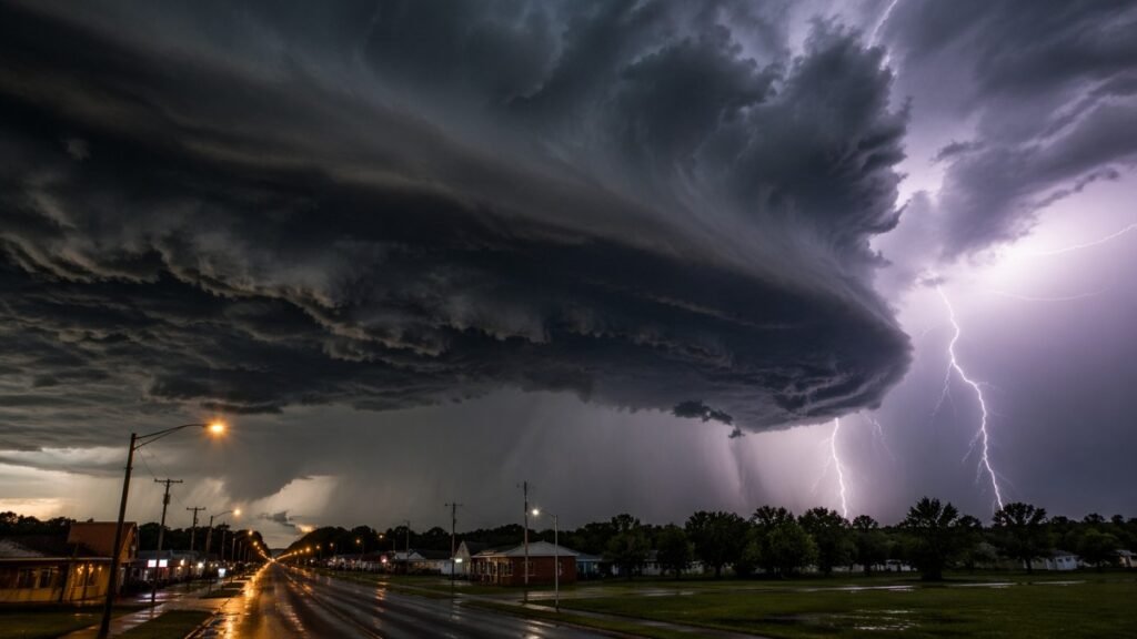
Image Credit: AI Generated
Areas Most at Risk
The most heavily impacted regions include northeastern Oklahoma counties such as:
- Tulsa
- Osage
- Pawnee
- Rogers
- Washington
- Nowata
- Craig
- Ottawa
These areas are positioned directly along the storm track and near the stalled frontal boundary, making them particularly vulnerable to repeated storm impacts.
Why This System Is Dangerous
This weather event is not a single storm but a multi-day system, which significantly increases its potential impact. The combination of atmospheric instability, moisture, and a stationary front creates ideal conditions for:
- Repeated thunderstorm development
- Strong updrafts capable of producing large hail
- Wind shear that can support tornado formation
Additionally, storms forming over the same areas repeatedly—known as “training storms”—can lead to dangerous flooding.
Safety Advisory for Residents
Officials are strongly urging residents across northeastern Oklahoma to remain vigilant and prepared. Key safety recommendations include:
- Monitor local weather updates continuously
- Keep mobile alerts enabled for emergency notifications
- Identify a safe shelter location in advance
- Avoid traveling during severe storm activity
- Never attempt to drive through flooded roads
Those in tornado-prone areas should have immediate access to a sturdy shelter, preferably an interior room on the lowest floor of a building.
Emergency Response and Preparedness
Local emergency management teams are on high alert as conditions evolve. Additional warnings and watches are expected to be issued as the system develops further overnight and into the weekend.
Meteorologists stress that weather conditions can change rapidly, especially during nighttime storms when visibility is limited. This makes early preparation and awareness even more critical.
Disclaimer
This article is based on currently available weather reports and official alerts at the time of publication. Weather conditions can change rapidly, and readers are advised to follow updates from local authorities and official meteorological agencies.
Images used in this article are for representational and illustrative purposes only. They may not depict the exact locations or real-time conditions mentioned in the report.
The publisher is not responsible for any decisions made based on this information. For safety guidance, always rely on official emergency services and local weather advisories.